
Use it to orient yourself among parks, older streets, the golf course, the high school area, and the canyon terrain.
New Braunfels neighborhood guide
Landa Park and central-west New Braunfels, block by block.
Spring-fed water, a large public park, steep canyon terrain, and older residential streets sit close together on the west side of the central city. The useful comparison starts with the parcel, the slope, and the drainage path.
Start with the map
This page describes an orientation area, not an official district.
Central-west New Braunfels has no single legal boundary. For this guide, the area means land inside New Braunfels city limits that falls within the ring formed by the Loop 337 and SH 46 arc and Interstate 35, sits west of Walnut Avenue, and lies outside the City of New Braunfels Downtown Boundary. That ring is an editorial reading aid used across this site so buyers can compare parts of the city consistently. It is not a zoning district, a subdivision, a school attendance zone, a taxing entity, or a neighborhood association.
Zoning, plat, historic overlay, city-limit, and district status all have to be confirmed parcel by parcel.
Downtown is covered separately using the city's own published Downtown Boundary map, and this guide sits outside it.
Two named historic districts, Sophienburg Hill and Mill Street, fall on or near the western side of the central city. The city describes Sophienburg Hill as covering the area platted by Alexander Rossy in 1856 including Academy Avenue, and Mill Street as covering town and acre lots distributed by the Verein in 1845 along West Mill Street and Ferguson Street. A property inside a historic district carries review requirements for exterior work, so district status is a title and permitting question rather than a marketing detail. Check the city's historic district information and the published district boundaries for the exact address.
Parks, water, and public land
Landa Park is the anchor, and it is a park, not a subdivision.
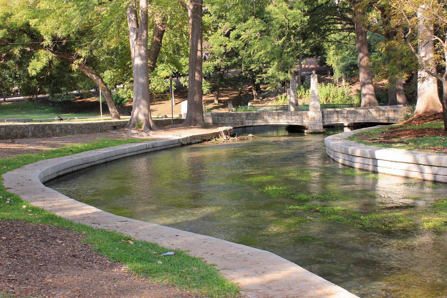
The City of New Braunfels describes Landa Park as a Lone Star Legacy Park with about 51 acres of amenities under oak canopy at 164 Landa Park Drive, open daily from 6am to 10pm. The city lists walking trails, three playgrounds, an outdoor amphitheater known as the Dance Slab, a miniature train, an arboretum, the Landa Park Aquatic Complex, the Wurstfest grounds, and Comal Springs. The park's history is documented too: Harry and Joseph Landa owned the property from 1847 to 1927 and developed it as a private park, and by 1898 railroad spurs brought visitors from San Antonio and across the state.
Comal Springs and the Comal River
Comal Springs is the largest concentration of naturally occurring freshwater springs in Texas, fed by the Edwards Aquifer through karst limestone. The Comal River begins at those springs in Landa Park and runs about 2.5 miles to its junction with the Guadalupe River, entirely inside New Braunfels city limits. Spring flow, aquifer conditions, and endangered-species habitat are actively managed here, which is one reason nearby public projects carry environmental design requirements.
Landa Park Aquatic Complex
The city operates three swimming areas at 350 Aquatic Circle: a 25-yard by 50-meter Olympic pool named for coach Bud Dallmann, a historic spring-fed pool built in the early 1900s that stays near 72 degrees year round, and a zero-depth pool that runs from 0 to about 2.5 feet. Hours, seasons, pass pricing, and rental rules change through the year, so check the city page before planning around them.
Landa Park Golf Course
The city's 18-hole public course at 180 Golf Course Road covers about 122 acres along the Comal River. It is a public facility rather than a private club amenity, so a nearby home does not carry membership, access rights, or a view easement. If a listing implies course frontage or a protected view, confirm the lot line, any easement, and the course's own boundary on the plat.
Panther Canyon Nature Trail
Panther Canyon covers about 49 acres beginning in Landa Park near the springs and running from Landa Park Drive to Ohio Avenue, with roughly 1.8 miles of trails. The city describes the trails ascending the Balcones Escarpment into the Edwards Plateau, with a relatively flat Canyon Trail and moderately strenuous Rim and North Rim segments. The canyon crosses an ephemeral creek bed that flows only during or right after rain, which is a useful signal about how water moves through this part of town.
The Landa Recreation Center sits at 164 Landa Park Drive and runs camps and youth programming, and the city's Das Rec facility offers year-round indoor pools and league play elsewhere in the city. Landa Haus is a climate-controlled event building in the park. None of these are private neighborhood amenities, and none of them attach to a particular address.
Housing and street context
Older stock, varied lots, and comparisons that need real detail.
Central-west New Braunfels is not a single housing product. Within a short drive you can find early twentieth century homes on platted town lots, mid-century construction on larger yards, small multifamily buildings, scattered infill, and remodels of very different quality. The city's own historic-district narratives note Craftsman bungalow examples from the 1920s on Academy Avenue and Tudor-style houses built in the 1930s, which gives a sense of how far back parts of the housing stock go.
Comparing an older house honestly
Two houses on the same street can price very differently for reasons that never appear in photos. Ask which systems were replaced and when, whether work was permitted, whether the foundation has been evaluated or repaired, what the sewer line is made of, and whether the roof and attic can handle the tree canopy above them. A general inspection is a starting point. On an older central home, a sewer scope, a foundation opinion, and a wood-destroying-insect report are often worth the added cost.
Remodels and additions
Additions on older lots can involve setbacks, easements, impervious-cover limits, and in some cases historic review. If the home you are comparing has a converted garage, an enclosed porch, a detached studio, or an accessory unit, confirm permit records and how the appraisal district and any lender treat that space. Square footage shown in a listing is not automatically the square footage a lender or appraiser will credit.
Lot, canopy, and setting
Mature oaks are part of the character of this area and part of the maintenance budget. Look at limb clearance over the roof, root proximity to foundations and lines, and who is responsible for trees near the right of way. Slope matters here too. A lot that sheds water toward the street behaves very differently from one that collects it at the back fence.
Rental and short-term use
Do not assume any property can be operated as a short-term rental. The City of New Braunfels runs a short-term rental registration and tax portal and levies a 7 percent hotel occupancy tax on qualifying stays, in addition to the state rate. Zoning, registration status, deed restrictions, lender terms, and insurance all have to line up before rental income belongs in a purchase analysis.
Terrain, flood, and drainage
The escarpment affects how water moves, not just how the view looks.
Central-west New Braunfels sits where the Balcones Escarpment meets the valley floor. The city describes Panther Canyon trails climbing from near the springs up into the Edwards Plateau, and Comal Springs discharges at roughly 620 feet of elevation. Elevation change over short distances means runoff concentrates quickly, and it means two nearby homes can have completely different water behavior.
Flood mapping is parcel level
Check the current FEMA flood map, the city's floodplain management information, any prior elevation certificate, the seller's disclosure, and an actual insurance quote for the address. A neighbor's premium, a general area reputation, and a listing remark are not evidence. Ask specifically whether the property has ever taken water and what documentation exists.
City floodplain managementCitywide drainage planning
The city received a Texas Water Development Board Flood Infrastructure Fund grant in 2020, not to exceed $1,106,781, and hired Freese and Nichols to produce a Drainage Area Master Plan. The stated goals include better understanding of flood risk, long-range planning to reduce it, and identifying regional flood control projects. Study recommendations are planning documents, not commitments to build a specific improvement near a specific house.
Drainage Area Master PlanWater quality work in the park
The city has described a Golf Course Road parking and biofiltration project adding 17 parking spaces along Golf Course Road plus a soil-media filtration system that treats stormwater from the road and new spaces before it reaches spring habitat. The work ties to the Edwards Aquifer Habitat Conservation Plan. Confirm current schedule and status with the city, because construction timing and traffic staging change.
Golf Course Road projectOwnership costs and restrictions
Build the cost picture from the parcel, not the area name.
Being inside New Braunfels city limits does not by itself produce a single tax bill, utility arrangement, or restriction set. The city reports a 2025 total property tax rate of $0.408936 per $100 of valuation, split between $0.193888 for debt service and $0.215048 for operations and maintenance, and it notes that it partners with the Comal County Tax Assessor-Collector to collect ad valorem taxes. The city rate is one line in a bill that also includes county, school, and any special district amounts.
Taxes and exemptions
Pull the current appraisal record for the exact parcel, list every taxing entity on it, and confirm exemption status rather than inheriting the seller's. A homestead or over-65 exemption held by a current owner does not transfer as a promise to the next owner. Ask your lender to underwrite the payment on unexempted values if the timing is uncertain.
City tax informationZoning and use
New Braunfels zoning governs land-use compatibility, and changes require an application, a Planning Commission public hearing, and two readings at City Council. Special Use Permits and variances follow their own processes. If your plan depends on a use the current zoning does not allow, treat approval as uncertain and time-consuming rather than a formality.
City zoning informationHistoric review
If the parcel sits in Sophienburg Hill, Mill Street, or another designated district or carries a landmark designation, exterior changes, demolition, additions, and signage can require review. Confirm designation status before pricing a renovation, and get the requirements in writing from the city rather than from a neighbor's experience.
Historic preservationDaily routes and public services
Drive the route, then verify the provider.
The practical value of a central-west address is short distances to the park, the river, downtown, and the Loop 337 and I-35 connections. That does not remove the need to test the route yourself. Tourist season, school arrival and dismissal, Wurstfest, river traffic, and active construction all change how the same streets feel at different hours.
Test the actual trip
Drive from the driveway, not from a map pin, at the times you will actually travel. Include the turn out of the neighborhood, the crossing you cannot avoid, and the section of Loop 337 or I-35 you will use. Do it twice on different days. Then check the city's capital project and thoroughfare planning information for work that could alter the route.
City capital programsUtilities
New Braunfels Utilities serves much of the incorporated city for electric, water, and wastewater, but confirm the service address, meter, connection, and any needed extension with the provider and the seller's documents. The city also publishes a utility provider contact list, which is a good reminder that provider territory near New Braunfels is not uniform.
NBU infrastructure portalSchools
Attendance is assigned by address and can be changed by the district. Verify the current assignment with the district before relying on a listing, a map widget, or a past assignment. This guide does not rate, rank, or compare schools, and school assignment should never be treated as fixed for the life of a home purchase.
Texas school district locatorParks access and permits
Park hours, pavilion and pool rentals, special-use permits for grills, amplified sound, and inflatables, and rules on pets, alcohol, and parking are all set by the city and change. If regular park use is part of why you want the address, read the current rules rather than assuming.
City Landa Park pageA buyer and seller working list
Questions worth answering before the decision gets emotional.
For buyers
- Is the address inside city limits, and which taxing entities appear on the current appraisal record?
- What does the current FEMA map, elevation data, and insurance quote say about this specific parcel?
- Is the property inside a historic district or subject to a landmark designation or overlay?
- What does permit history show about the remodel, addition, garage conversion, or accessory structure?
- Where does water leave the lot, and what happens to it during a heavy rain?
- Which utility providers actually serve the address, and is the connection active and adequate?
- How does the route to work and school behave on a normal weekday and during river season?
For sellers
- Can you document the updates you plan to advertise, with dates and permits where they exist?
- Are survey, plat, easement, and any elevation certificate documents assembled before listing?
- Does your pricing account for condition, slope, drainage history, and the competing inventory nearby?
- Are historic-district or zoning constraints disclosed accurately rather than left for the buyer to discover?
- Have you described park and river proximity as location, not as private amenity or guaranteed view?
- Are known drainage, tree, foundation, or sewer issues addressed with records rather than adjectives?
The New Braunfels area guide remains the comparison hub for citywide taxes, utilities, growth areas, and property-level due diligence. For dated citywide context, see the New Braunfels City Report 2026, and for the adjacent central area see the Downtown New Braunfels guide. If you want the utility side handled before closing, the New Braunfels utility checklist walks through it.
Common questions
Landa Park and central-west New Braunfels FAQs
What area does this Landa Park and central-west New Braunfels guide cover?
It covers land inside New Braunfels city limits that falls within the editorial orientation ring formed by the Loop 337 and SH 46 arc and Interstate 35, west of Walnut Avenue, and outside the City of New Braunfels Downtown Boundary. That ring is a reading aid used on this site, not an official neighborhood, district, or zoning boundary. Confirm jurisdiction, zoning, and district status for the exact parcel.
Is Landa Park itself a neighborhood?
No. Landa Park is a city park of roughly 51 acres at 164 Landa Park Drive, operated by New Braunfels Parks and Recreation. Homes described as being near Landa Park sit in several different subdivisions, plats, and zoning districts around it. Proximity to the park does not establish a shared HOA, tax stack, plat, or school assignment.
Does an address in this area sit in a floodplain?
Flood status is parcel specific. The Comal River, Comal Springs, Blieders Creek, Dry Comal Creek, and local storm drainage all run through parts of central-west New Braunfels, and elevation changes across the Balcones Escarpment are significant here. Check the current FEMA map, the city floodplain and drainage information, any elevation certificate, and the insurance quote for the specific address before making assumptions.
Which school district serves this part of New Braunfels?
Central-west New Braunfels addresses are commonly served by New Braunfels ISD, but attendance is assigned by address and can change. Verify the current assignment directly with the district for the exact address rather than relying on a listing, a portal map, or a prior owner's experience. This guide does not rate or compare schools.
Who provides water, wastewater, and electric service here?
New Braunfels Utilities serves much of the incorporated city, but service territory, meter status, connection type, and any required extension still have to be confirmed for the parcel. The city also publishes a utility provider contact list because platting and service coordination can involve several agencies in and around New Braunfels.
What should a buyer check on an older central-west home?
Treat age as a scope question rather than a defect. Useful items include permit history for visible work, foundation performance on sloped or clay-influenced lots, supply and drain lines, electrical service capacity, roof and attic condition, tree health and canopy over the roofline, lot drainage and where water leaves the property, and whether any structure sits inside a historic district or overlay that affects exterior changes.
Sources and review notes
Primary sources used for this guide
Reviewed August 7, 2026. Boundaries, park hours, tax rates, project schedules, utility territory, school assignments, and property conditions all change. Verify the original source and the exact address before acting on anything here.
City parks and public facilities
Property, risk, and regulation
Compare the actual address
Bring the property, not just the area name.
Velvet Realty Group can help organize the records, routes, comparable homes, and questions that apply to a specific Landa Park or central-west New Braunfels address.