
Cibolo Service Area · Area Guide
Downtown Cibolo and FM 78: roads, water districts, and Old Town
Three of the answers a downtown Cibolo buyer needs are published by more than one office, and the copies do not always agree. This page reads each one from its publisher and says which office holds the version that governs.
The short version. Downtown Cibolo sits on the FM 1103 corridor that runs from I-35 to FM 78. TxDOT is rebuilding it, and the city and TxDOT publish finish dates four years apart. The city is served by two water districts,4 and which one covers a parcel changes what the bill looks like.
Downtown Cibolo is a way of talking about the older part of town around Main Street. It is not an address field, and nobody at the city will confirm that a house is or is not in it. What the city does publish are the things that decide a monthly bill and a morning drive: which utility district serves a parcel, what the city still bills for, where the construction is, and which of its planning boundaries currently apply.
Everything below was read from its publisher on 2026-09-03. Where an answer is address-specific rather than area-wide, this page says so and names the office holding the record instead of guessing.
The same road has two published finish dates
TxDOT is rebuilding FM 1103, the corridor that carries traffic from I-35 down through town toward FM 78. The agency describes the work as expanding FM 1103 from a two-lane roadway to a four-lane roadway with center turn lane, with pedestrian accommodations of six foot sidewalks in each direction and bicyclist accommodations of five foot bike lanes in each direction.2
Both the city and the state publish a schedule for it, and both begin the sentence the same way. The City of Cibolo road page states that construction started in November 2022 is estimated to be completed in late 2025 or early 2026.1 TxDOT's page for the same project states that construction started in November 2022 is estimated to be completed in Fall 2029.2
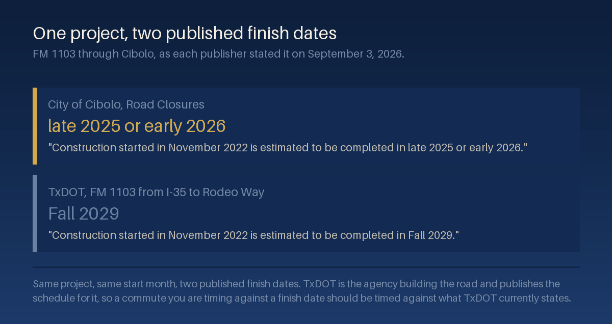
We are not in a position to settle that, and neither page mentions the other. What we can say is which one owns the schedule. TxDOT is building the road and publishes the project page for it, so if you are timing a Cibolo commute against a finish date, read it from TxDOT's own project page on the day you need it rather than from a summary.2 Either way, any drive you time on this corridor today is a construction-period drive.
The stretch closest to downtown is a separate TxDOT project. FM 1103 from Rodeo Way to FM 78, in Guadalupe County, is described as four 11-foot lanes with an additional continuous two-way left turn lane or raised center median, curbs, shared-use paths, turning lanes at intersections, and drainage improvements. TxDOT states the needed right of way ranges from 120 to 135 feet and that no residential or non-residential structures are anticipated to be displaced at this time, and it directs schedule questions for right-of-way acquisition and construction to its district office.3
If you are looking at a house that fronts this corridor, the right-of-way width is the number to ask about at the district office, because it is the one that can reach a front yard.
Which water district serves the address, before anything else
The City of Cibolo states that the city is served by two water districts, the City of Cibolo and Green Valley Special Utility District, and asks residents to contact the Utility Administration Department to find out which district covers their area.4 That is not a formality. It changes who sends the bill and what is on it.
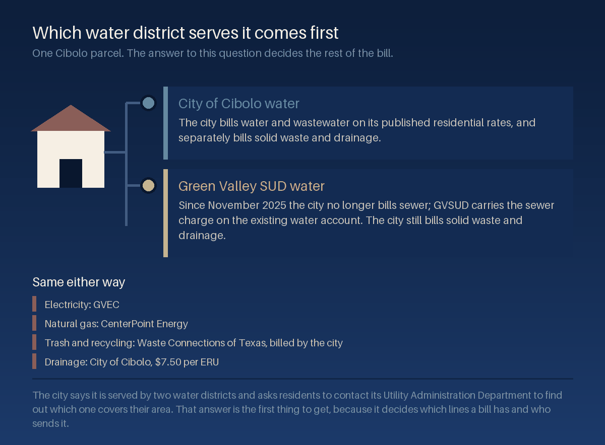
Since November 2025 the city no longer bills for sewer service; Green Valley Special Utility District includes the sewer charge on the existing water account instead. The city continues billing separately for solid waste and drainage fees.5 So a Cibolo household can receive one combined water and sewer bill from a utility district plus a city bill for two other services, and the seller's copy of last month's bill is the fastest way to see which shape applies.
The city fees are published. Drainage is charged on impervious surface: the city gives the average impervious area for a single family property as 2,889 square feet, calls that one Equivalent Residential Unit, and charges $7.50 per ERU across four tiers running from 0.7 ERU for up to 2,217 square feet to 2.0 ERU above 8,000 square feet.6 Residential garbage service for a single family home is published at $22.73 per month, with additional carts priced separately.6
An older house on a small lot and a newer one on a wide driveway can therefore sit in different drainage tiers on the same street. It is a small line on a bill, but it is one you can check before you write an offer instead of after.
The providers that do not change
Electricity and gas are simpler here than in some neighboring cities. The city names Guadalupe Valley Electric Cooperative as the primary electricity provider for the City of Cibolo,8 and CenterPoint Energy as the primary natural gas provider for residential and commercial users within the city.9
Trash changed hands recently. The city records that on May 13, 2025 the City Council approved a solid waste and recycling franchise agreement with Waste Connections of Texas, LLC, doing business as Vaquero, with service beginning July 28, 2025 under a five-year term and an option for one five-year extension.7 Each residential address receives one 95-gallon trash cart and one 95-gallon recycling cart, collection is once a week with recycling on the same day, and brush and bulky waste are collected every other week citywide with branches limited to four feet in length and four inches in diameter and construction debris excluded.7
If you are buying a house with a workshop or a long-running renovation in it, that last exclusion is the one worth reading twice.
Cibolo water is not San Antonio water, and the yard rule is its own
The city states that it receives its drinking water from the Canyon Regional Water Authority, and that the water delivered to the city comes from two sources, the Guadalupe River and the Carrizo Aquifer, which it describes as substantially more drought-resistant than the Edwards Aquifer where San Antonio produces a majority of its drinking water.4
The city follows that with a sentence people skip: its water usage rules and restrictions are not set by the City of San Antonio or SAWS and can differ significantly from theirs during periods of reduced rainfall.4 Read the second half of that as carefully as the first. A different supply is not a lighter rulebook, and Cibolo publishes its own.
The published irrigation rules run on two seasons and one weekly rule. During the period from April 1 to October 31, the use of irrigation systems is restricted between 10 a.m. and 8 p.m. During the period from November 1 to March 31, they are restricted between 10 a.m. and 2 p.m. No sprinkler use on Sundays.4 The city also asks customers to read its drought contingency plan, and it tells households served by Green Valley Special Utility District to follow the conservation measures that district publishes instead.4
Set an irrigation controller once, in the season you close, and you have handled it. Buy in March and forget to re-check in April, and the window moves under you.
Old Town has a boundary the city says has not been drawn consistently
Cibolo's downtown carries a zoning overlay. The city writes that the area includes approximately 188 lots and was formally established as the Old Town Mixed Use Overlay District in 2010, and that since its adoption the boundaries of Old Town have been depicted inconsistently across the City's Zoning Map and Future Land Use Map.10
That sentence is unusual for a city to publish, and it is worth taking at face value. Where a published boundary disagrees with itself across two official maps, a screenshot of either one is not an answer for a specific parcel. Take the address to the Planning Department and ask what overlay, if any, currently applies to it, and get the reply in writing before an option period runs out.
The city is in the middle of fixing it. Cibolo, working with Lionheart Places, is updating the Cibolo Downtown Revitalization Plan originally adopted in 2014 through an Old Town Master Plan, and states that the plan will define a clear vision and the boundaries for the Old Town district while prioritizing pedestrian access, mobility, land use, zoning, and infrastructure. The published schedule runs in four phases, Think in March 2025, Investigate from April to July 2025, Create from August to December 2025, and Share from January to May 2026, with an anticipated duration of twelve to eighteen months.10
Above that sits the 2024 Cibolo Tomorrow Comprehensive Plan, adopted on September 10, 2024 by Ordinance 1465, alongside a Unified Development Code rewrite the city also lists as in progress.11 Zoning text and zoning maps both move during a rewrite, which is a reason to confirm a parcel's status on the day you need it rather than relying on a document downloaded earlier in a search.
City limits, ETJ, and flood status are all parcel questions
A Cibolo mailing address does not settle whether a property is inside the city. The city's planning FAQ points residents to its online maps to view city limits and extraterritorial jurisdiction boundaries and notes that some Cibolo addresses fall outside the corporate city limits.12 Inside or outside changes which rules and which services attach to the land, so it is a first question rather than a detail.
Flood status works the same way. The city's answer is to go to the Federal Emergency Management Agency website or contact Cibolo Planning and Zoning staff members to determine whether a home is in a floodplain.12 The effective panel and zone for a specific address sit with FEMA's map service center, and they are an input that a lender and an insurer each review under their own requirements and underwriting.13
We do not state any property's flood status on this page, and no page can. Pull the parcel, confirm the panel and the zone, and take both to your lender and an insurance agent during the option period so you know what they mean for the file while you can still act on it.
One more record worth knowing about: the city explains that a plat is the official map of an addition or subdivision showing lots, public rights-of-way, and easements, and that under the Texas Local Government Code platting is not required where parcels exceed five acres each, each has public street access, and no public improvements are dedicated.12 On the larger lots at the edges of town, that is the difference between a recorded plat and no plat at all.
What changes with the county, ZIP, school, and tax side
None of the above covers the jurisdiction stack. The ZIP area, the city a parcel is actually in, the school district, and the published tax rates are their own subject, and repeating them here would only give them a second place to go stale. They live in one place instead: the Cibolo ZIP codes, city limits, schools, and taxes guide carries the ZIP areas that reach city land, the tax stack as published, and the reason 78108 is not the same thing as the City of Cibolo.
Read the two together. That page tells you what a parcel's jurisdiction costs. This page tells you who to call about the road, the water, the bill, and the overlay.
How to check a specific address
| Which water district serves it | The City of Cibolo Utility Administration Department. The city says it is served by two water districts and asks residents to contact that department for their area.4 |
|---|---|
| Who bills sewer | Green Valley Special Utility District carries the sewer charge on the water account; the city bills solid waste and drainage.5 Ask the seller for a recent bill from the property. |
| What the city fees come to | Drainage at $7.50 per ERU on the published tier for the parcel's impervious area, and residential garbage at $22.73 per month for a single family home.6 |
| Which electricity and gas providers serve it | GVEC for electricity8 and CenterPoint Energy for natural gas,9 as the city names them. Confirm the account with the provider before assuming a cost carries over. |
| When the road work on FM 1103 is expected to close out | TxDOT's project page, read on the day you need it.2 The district office holds the right-of-way and construction schedule for the Rodeo Way to FM 78 segment.3 |
| Whether it sits in the Old Town overlay | The Planning Department, in writing. The city states the boundaries have been depicted inconsistently across two of its own maps.10 |
| Whether it is inside the city limits or the ETJ | The city's online maps section, which publishes both.12 |
| Whether it sits in a flood zone | FEMA's map service center for the effective panel and zone,13 or Cibolo Planning and Zoning staff.12 |
| Its ZIP area, school district, and taxing units | The appraisal district record for the parcel, which names the units billing it. The Cibolo jurisdiction guide linked above walks through the ZIP and tax side. |
What this guide does not do
It does not draw a boundary for downtown Cibolo, and it does not draw one for the Old Town overlay either, because the city says its own two maps disagree. It does not state any property's flood status, utility district, drainage tier, or overlay status, because all four are parcel-level facts held by offices other than us. It is not legal, tax, insurance, or engineering advice, and it does not replace the city, the county, TxDOT, FEMA, the appraisal district, or a licensed inspector.
It carries no valuation and no forecast. Nothing here says what a home on this corridor is worth or what a purchase will return. And it says nothing about any school, any neighborhood, or the people who live in either.
Questions we get about downtown Cibolo
Is downtown Cibolo an official district?
Not as a name. There is a zoning overlay covering the older part of town, the Old Town Mixed Use Overlay District, established in 2010 and covering approximately 188 lots.10 Whether one parcel is inside it is a question for the Planning Department rather than for a map screenshot.
When does the FM 1103 construction end?
The two publishers give different answers. The city page says construction started in November 2022 is estimated to be completed in late 2025 or early 2026,1 and TxDOT's project page for the same work says Fall 2029.2 TxDOT is the agency building it, so check its page on the day the answer matters to you.
Do I get my water from the city?
Maybe. Cibolo is served by two water districts, the city and Green Valley Special Utility District, and the city asks residents to contact its Utility Administration Department to find out which one covers their area.4
Are there watering restrictions in Cibolo?
Yes, and they are the city's own rather than San Antonio's. Irrigation systems are restricted between 10 a.m. and 8 p.m. during the period from April 1 to October 31, and between 10 a.m. and 2 p.m. from November 1 to March 31. No sprinkler use on Sundays.4
Who picks up the trash?
Waste Connections of Texas, under a franchise agreement the City Council approved on May 13, 2025 with service beginning July 28, 2025.7 Brush and bulky collection runs every other week citywide.7
Does a Cibolo address mean the house is in the city?
No. The city's planning FAQ says some Cibolo addresses fall outside the corporate city limits and points to its online maps for the city limit and extraterritorial jurisdiction boundaries.12
Related guides
This page sits under the Cibolo service area hub, which links the rest of what we publish on the city. For the ZIP, city limit, school district, and tax side, read living in Cibolo.
The companion guide one city over runs the same checks on the neighboring corridor: the central Schertz and FM 78 area guide covers a city where the electric provider changes with the address and flood mapping spans three counties. For taxes generally, our Texas property tax guide explains how the pieces fit together statewide.
Primary sources
Numbered markers in the text above point into this list. Each entry is the publisher's own page, and each was read on the date shown.
- City of Cibolo, Road Closures. The city's FM 1103 summary, including its statement that construction started in November 2022 is estimated to be completed in late 2025 or early 2026, and its I-35 NEX description. Retrieved 2026-09-03.
- TxDOT, FM 1103 from I-35 to Rodeo Way. The two-lane to four-lane expansion with center turn lane, the six foot sidewalks and five foot bike lanes in each direction, the November 2022 construction start, and the estimated completion of Fall 2029. Retrieved 2026-09-03.
- TxDOT, FM 1103 from Rodeo Way to FM 78. The Guadalupe County limits, the four 11-foot lanes with a two-way left turn lane or raised median, curbs and shared-use paths, the 120 to 135 foot right of way, the statement that no structures are anticipated to be displaced at this time, and the district office as the schedule contact. Retrieved 2026-09-03.
- City of Cibolo, Water Information. The two water districts and the Utility Administration Department referral, the Canyon Regional Water Authority supply drawn from the Guadalupe River and the Carrizo Aquifer, the comparison the city draws with the Edwards Aquifer and SAWS, the seasonal irrigation windows, the Sunday sprinkler rule, and the direction to Green Valley Special Utility District customers. Retrieved 2026-09-03.
- City of Cibolo, Utility Services. The November 2025 change under which the city no longer bills sewer and Green Valley Special Utility District carries the charge on the water account, and the city's statement that it continues billing separately for solid waste and drainage fees. Retrieved 2026-09-03.
- City of Cibolo, Residential Rates. The drainage fee definition, the 2,889 square feet average impervious area used as the Equivalent Residential Unit, the $7.50 per ERU rate, the four size tiers, and the $22.73 per month single family garbage rate. Retrieved 2026-09-03.
- City of Cibolo, Waste Connections. The May 13, 2025 council approval of the franchise agreement with Waste Connections of Texas, LLC, the July 28, 2025 service start, the five-year term with one five-year extension option, the two 95-gallon carts, the weekly collection, and the every-other-week brush and bulky rules with their size limits and construction debris exclusion. Retrieved 2026-09-03.
- City of Cibolo, Electricity. Guadalupe Valley Electric Cooperative named as the primary electricity provider for the City of Cibolo. Retrieved 2026-09-03.
- City of Cibolo, Gas. CenterPoint Energy named as the primary natural gas provider for residential and commercial users within the City of Cibolo. Retrieved 2026-09-03.
- City of Cibolo, Old Town Master Plan. The approximately 188 lots, the 2010 establishment of the Old Town Mixed Use Overlay District, the statement that the boundaries have been depicted inconsistently across the City's Zoning Map and Future Land Use Map, the update to the Cibolo Downtown Revitalization Plan originally adopted in 2014, the Lionheart Places collaboration, the four project phases and their months, and the twelve to eighteen month duration. Retrieved 2026-09-03.
- City of Cibolo, Long Range Planning. The 2024 Cibolo Tomorrow Comprehensive Plan adopted on September 10, 2024 by Ordinance 1465, and the Unified Development Code rewrite listed alongside it. Retrieved 2026-09-03.
- City of Cibolo, Planning FAQs. The direction to FEMA or Cibolo Planning and Zoning staff for a floodplain determination, the online maps for city limits and extraterritorial jurisdiction with the note that some Cibolo addresses fall outside the corporate city limits, and the plat definition with the Texas Local Government Code exception for parcels over five acres. Retrieved 2026-09-03.
- FEMA Flood Map Service Center. The federal source for the effective flood map panel and zone covering a specific address, which is the record a lender and an insurer each read independently. Retrieved 2026-09-03.
Provenance and review
| Sources read on | 2026-09-03. Every figure above was read from the publisher named beside it on that date, not carried over from an earlier draft. |
|---|---|
| Published | 2026-09-04 |
| Last reviewed | 2026-09-04 |
| Next review due | 2026-12-01. The FM 1103 dates, the Old Town Master Plan status, and the published utility rates are the volatile items here, and all three should be re-read before this page is reused. |
| Corrections | If a figure on this page does not match its source, tell us and we will correct the page, restate the corrected figure, and update the review date above. |
Bring the address, not just the area name
An area guide can tell you that Cibolo has two water districts,4 a road with two published finish dates, and an overlay boundary the city says its own maps draw differently. It cannot tell you which of each applies to one house. Send us the address and we will pull the parcel record, run the utility, drainage, overlay, and flood questions against it, and give you the dated answers with the office that published each one.
Get the address-level version of this page.
Tell us the street and we will send the water district, the drainage tier, the overlay status, and the city limit answer for that parcel, each with the office that publishes it and the date we read it.