
Velvet Realty Group Blog
Living in Schertz, TX: Counties, ZIP Codes, Schools, and Taxes
One city, three county tax rolls, five ZIP areas, and five school districts. Which of each a Schertz address lands in is a question about the parcel, not about the mailing address, and this page shows where each answer is published.
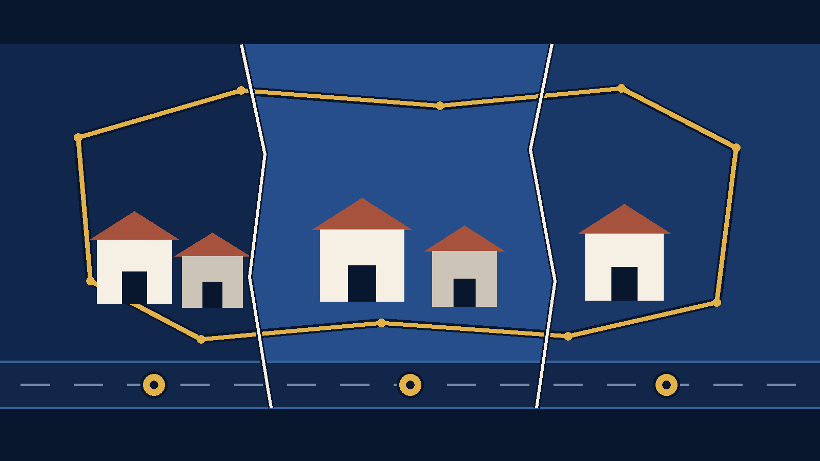
The short version. Schertz sits in three counties. Guadalupe, Comal, and Bexar each publish their own tax rate, each pairs the city with a different school district, and each is valued by a different appraisal district. Five ZIP areas cover city land, and the ZIP printed on the mail decides none of it.
Most cities have one county, one appraisal district, one set of county offices. Schertz has three of each. That is the fact worth knowing before you compare two Schertz listings, because two houses with the same mailing city can sit on different tax rolls, be valued by different offices, and be zoned to different school districts.
This page collects what the public record says, names the office that publishes each piece, and dates it. Where an answer is address-specific rather than citywide, it says so and points at the lookup rather than guessing.
One city, three tax stacks
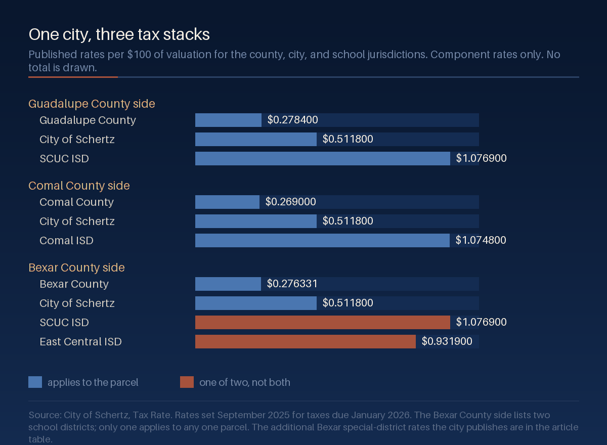
The City of Schertz publishes its tax rate as three separate lists, one for each county its land falls in. The city's own rate is identical on all three at $0.511800 per $100 of valuation. Almost everything around it changes.
| County side | Jurisdiction | Rate per $100 |
|---|---|---|
| Guadalupe | Guadalupe County | $0.278400 |
| Lateral Road | $0.052000 | |
| City of Schertz | $0.511800 | |
| SCUC ISD | $1.076900 | |
| Comal | Comal County | $0.269000 |
| Lateral Road | $0.036015 | |
| City of Schertz | $0.511800 | |
| Comal ISD | $1.074800 | |
| Bexar | Bexar County | $0.276331 |
| City of Schertz | $0.511800 | |
| SCUC ISD (one of two) | $1.076900 | |
| East Central ISD (one of two) | $0.931900 | |
| Flood Fund | $0.023668 | |
| San Antonio River Authority | $0.018300 | |
| Hospital District | $0.276235 | |
| Alamo Community College | $0.149150 |
Two things in that table are easy to misread.
The Bexar side lists two school districts. That is not a parcel paying both. It is the city listing the two districts that appear on its Bexar-side properties, and any one parcel is in one of them. The city's page says outright that the Bexar County side has multiple school and special taxing districts and that exact cumulative rates need to be verified individually.
The Bexar side also carries four line items the other two sides do not: the flood control fund, the San Antonio River Authority, the hospital district, and Alamo Community College. The Guadalupe and Comal sides instead carry a Lateral Road rate, at two different amounts. So the sides are not three versions of the same list. They are three different lists.
Adding the line items the city prints for each side gives the following. This is our arithmetic on published rates, not a published total, it assumes every listed jurisdiction applies, and it is before any exemption:
| County side | School district assumed | Sum of listed rates per $100 |
|---|---|---|
| Guadalupe | SCUC ISD | $1.919100 |
| Comal | Comal ISD | $1.891615 |
| Bexar | SCUC ISD | $2.332384 |
| Bexar | East Central ISD | $2.187384 |
Treat those four numbers as a reason to check, not as an answer. Exemptions change what is actually owed, the city's Bexar list may not be exhaustive for a given parcel, and only the appraisal district holding the parcel can state its jurisdictions. What the sums do show is that the spread between the three sides is real and is larger than the difference between the county rates alone, which sit within about a cent of each other.
Five ZIP Codes cover Schertz land
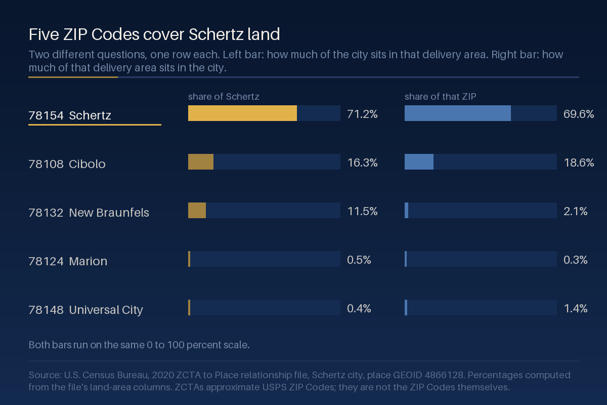
The Census Bureau publishes a file that measures how much land two geographies share. Run Schertz through it and five ZIP Code Tabulation Areas come back. The city covers about 83.1 square kilometers, or 32.08 square miles, of land, and that land is split across all five.
| ZCTA | Usual place name | Share of Schertz land | Share of that ZCTA inside Schertz |
|---|---|---|---|
| 78154 | Schertz | 71.2% | 69.6% |
| 78108 | Cibolo | 16.3% | 18.6% |
| 78132 | New Braunfels | 11.5% | 2.1% |
| 78124 | Marion | 0.5% | 0.3% |
| 78148 | Universal City | 0.4% | 1.4% |
Read the two columns as separate questions, because they answer different things. 78154 is the ZIP most people mean by "Schertz," and it holds 71.2% of the city's land. But only 69.6% of 78154 is inside the city limits: roughly three tenths of that delivery area is somewhere else.
The 78132 row is the sharpest version of the same point. Just under 12% of Schertz land sits in a New Braunfels delivery area, while that slice is only 2.1% of 78132. A house there has a New Braunfels ZIP, is inside the City of Schertz, and sits in Comal County, which by the table above means Comal ISD and the Comal side's tax list. Nothing about the mailing address says any of that.
This is also why a ZIP-level market figure and a city-level question are not the same question. Our Universal City housing snapshot works entirely at ZIP level and says so; it reports 78154 alongside its neighbors, and 78154 is not the City of Schertz.
School districts do not stop at the city line
The City of Schertz says the city sits within five school districts, and names three that cover the majority of it: Schertz-Cibolo-Universal City ISD, Comal ISD, and East Central ISD. Those are the same three that appear in the tax table above, which is not a coincidence: the school rate on a parcel is set by whichever district the parcel is zoned to.
The city's education page describes the general areas each district covers but does not offer an address lookup. So a district cannot be inferred from a subdivision name, a ZIP, or a neighboring house. Confirm it with the district itself or the appraisal district record for the parcel, and confirm it again before an offer if the answer matters to you. Attendance boundaries are set by the districts and are revised from time to time.
We publish district boundaries and the offices that set them. We do not publish school ratings, rankings, or characterizations of any school, district, or the people who live in an area, and we do not use them to steer anyone toward or away from a neighborhood. If you want to evaluate schools, the Texas Education Agency publishes report cards and the districts publish their own boundary maps, and both are linked below.
How to check a specific address
Four separate offices answer four separate questions. In practice the appraisal district record answers most of them at once, because it names the jurisdictions billing the parcel.
| Which county the parcel is in | The appraisal district that holds the record. Guadalupe Appraisal District, Comal Appraisal District, or Bexar Central Appraisal District. Each offers a public property search by address. |
|---|---|
| Which jurisdictions tax it | The same appraisal district record. It lists the taxing units for the parcel, which is the authoritative version of the table above. |
| Whether it is inside the city limits | The City of Schertz. A Schertz mailing address is not the same thing as being inside the city, and the 78154 row above is the reason. |
| Which school district it is zoned to | The district itself. SCUC ISD, Comal ISD, and East Central ISD each publish attendance information, and the appraisal district record names the district billing the parcel. |
| The current rates | The City of Schertz tax rate page for the city's own list, and the county for the county's adopted rate. Texas rates are adopted annually in late summer, so a rate read in August may be superseded in September. |
One caution on the appraisal districts themselves. Comal Appraisal District publishes that it handles local property tax appraisal and exemption administration for 39 jurisdictions or taxing units. A parcel's record therefore names the specific taxing units billing that parcel, and that list, rather than the table above, is what to read.
What this page is not
It is not tax advice, and it is not an estimate of anyone's tax bill. The rates above are the published rates for a valuation, before any exemption, and a homestead or other exemption changes what is owed. Our Texas homestead exemption guide covers that side.
The rates are also dated. They were set in September 2025 for taxes due January 2026. Texas taxing units adopt new rates in the late summer, so this page carries an October 1 review date rather than an annual one.
ZCTAs are not ZIP Codes. A ZIP Code is a set of USPS delivery routes with no official area; a ZCTA is the Census Bureau's area approximation of one, built from census blocks. They line up closely enough to reason with and not closely enough to survey with. The shares in that table are land-area shares and say nothing about how many homes or people sit in each piece.
Nothing here is a valuation of any property, and nothing here is a statement about any school, neighborhood, or the people in it.
Where these figures come from
| Tax rates | City of Schertz, Tax Rate page. Transcribed at the precision the city publishes, including the trailing zeros. Rates set September 2025 for taxes due January 2026. |
|---|---|
| ZIP shares | U.S. Census Bureau, 2020 ZCTA-to-place relationship file, Schertz city, place GEOID 4866128. We downloaded the national file and read the five rows for that GEOID, then computed each share from the file's own land-area columns in square metres. Percentages are rounded to one decimal place and the five shares of Schertz land sum to 100% of the file's stated place land area. |
| Land area | 83,077,032 square metres, the place land area in the same file. Converted here to 83.08 square kilometers and 32.08 square miles. |
| School districts | City of Schertz, Education page, for the count of districts and the three named. No ranking, rating, or quality claim is made or implied. |
| Retrieved and verified | 2026-08-27 |
| Published | 2026-08-28 |
| Last reviewed | 2026-08-28 |
| Next review due | 2026-10-01, after Texas taxing units adopt rates for the following year. The rates on this page expire then and should be re-sourced before reuse. |
| Corrections | If a figure on this page does not match its source, tell us and we will correct the page, restate the corrected figure, and update the review date above. |
Sources
- City of Schertz, Tax Rate. Every rate in the tax table, and the city's own note that Bexar County has multiple school and special taxing districts requiring individual verification. Retrieved 2026-08-27.
- U.S. Census Bureau, 2020 ZCTA to Place relationship file (national, pipe-delimited text). The file itself, from which the five ZCTA rows and every share were computed. Downloaded and read 2026-08-27.
- City of Schertz, Education. The count of school districts and the three named districts. Retrieved 2026-08-27.
- Guadalupe Appraisal District, with a public property search by address. Retrieved 2026-08-27.
- Comal Appraisal District, with a public property search, and its district information page stating that it handles local property tax appraisal and exemption administration for 39 jurisdictions or taxing units. Retrieved 2026-08-27.
- Bexar Central Appraisal District, with property search by name, address, or property ID. Retrieved 2026-08-27.
- Texas Education Agency, TXschools.gov, the state's own school and district report cards, for readers evaluating schools directly.
Related guides
The Schertz service area hub links the rest of what we publish on the city. For the move itself rather than the jurisdictions, moving to Schertz in 2026 covers the practical side, and the pre-listing repair checklist for Universal City and Schertz covers preparation if you are the one selling.
Two neighbors share ZIP area with Schertz and have their own hubs: Cibolo and Universal City, and living in Universal City works through the same ZIP-versus-city-limits problem from the other side of the line. For taxes generally, our Texas property tax guide explains how the pieces fit together statewide.
Ask for the version with your address in it
A citywide page can tell you that Schertz has three tax stacks. It cannot tell you which one a particular house is on. Send us the address and we will pull the appraisal district record, read its taxing units and school district off the source, and give you the dated version with the links attached.
Get the jurisdiction facts for a specific address.
Tell us the street and we will send the county, the taxing units, and the school district for that parcel, each with the office that publishes it and the date we read it.